Emerging Bike Network
Piecemeal bicycle facilities don’t do much to increase ridership because they do little to connect origins to destinations. The City does not typically install on-street bike facilities unless the street is being resurfaced or rebuilt anyway, resulting in a patchwork of bike facilities. However, it is an exciting time to be a bike commuter in Little Rock, because this patchwork is starting to connect.
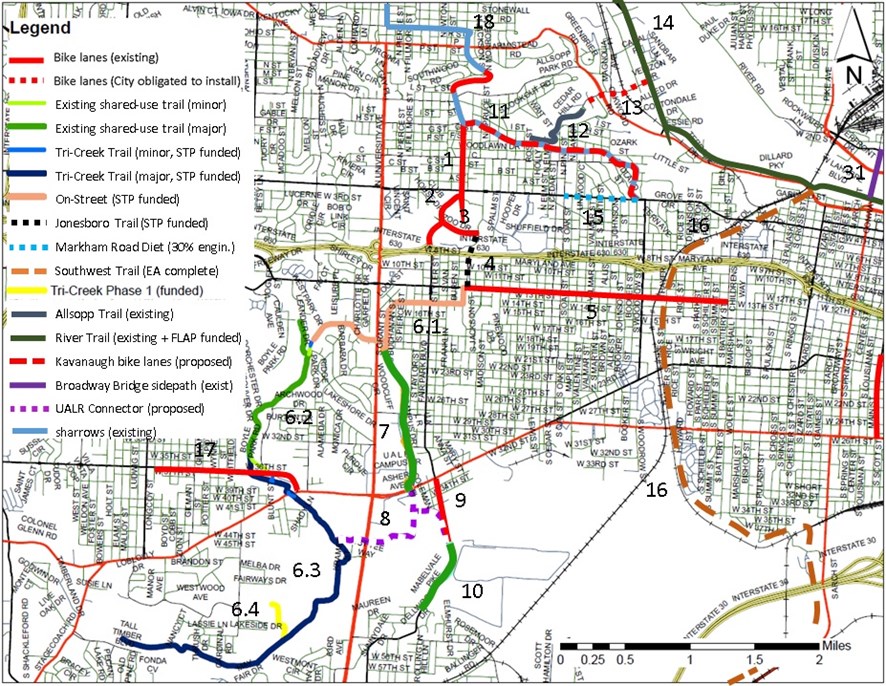
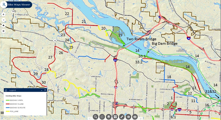
This page discusses a continuous network that either exists or is in some stage of being constructed.

Figure 1. Close up of the emerging, continuous network in the core of urban Little Rock.

Figure 2. The emerging, continuous network in the core of urban Little Rock zoomed out from the BikeWays LR basemap.
| # | Street / Park | Scope | Type | State | Length |
| 1 | Van Buren | Markham to Kavanaugh | bike lanes | existing | 0.5 miles |
| 2 | Fair Park | I-630 to Markham | bike lanes | existing | 0.5 miles |
| 3 | Zoo Drive | Monroe to Fair Park | bike lanes | existing | 0.3 miles |
| 4.1 | Jonesboro Trail | 12th St. to Marietta Ct. | trail | funded | 0.3 miles |
| 4.2 | Jonesboro Trail | Marietta Ct. to Zoo Drive | sharrows | funded | 0.2 miles |
| 5 | 12th Street | Jonesboro to Battery | bike lanes | existing | 2.0 miles |
| 6.1 | Tri-Creek Greenway P3 | 12th St. to Boyle Park | sharrows | funded | 1.8 miles |
| 6.2 | Tri-Creek Greenway | Boyle Park | trail | existing | 1.6 miles |
| 6.3 | Tri-Creek Greenway P3 | Boyle Park to Brodie Creek Park | trail | funded | 3.6 miles |
| 6.4 | Tri-Creek Greenway P1 | Western Hills Park | trail | funded | 0.5 miles |
| 7 | Coleman Creek Trail | Asher Ave. to Charles Bussey Ave. | trail | existing | 1.1 miles |
| 8 | UALR Connection | First Tee to Asher tp Mabelvale Pike | trail | NOT funded | 0.7 miles* |
| 9 | Mabelvale Pike bikelanes | Mabelvale Pike Trail to Asher Ave. | bike lanes | existing | 0.5 miles* |
| 10 | Mabelvale Pike trail | Mabelvale Pike bike lanes to 49th St. | trail | existing | 0.6 miles* |
| 11 | Kavanaugh | Markham to Rose | prot. bike lane | proposed | 0.9 miles |
| 11 | Kavanaugh | Rose to Hillcrest Square | sharrows | existing | 0.6 miles |
| 11 | Kavanaugh | Hillcrest Square to Van Buren | prot. bike lane | proposed | 0.2 miles |
| 12 | Allsopp Trail | Kavanaugh&Rose to Cedar Hill Dr. | trail | existing | 0.7 miles |
| 13 | Cedar Hill | Allsopp Park to Riverfront Dr. | bike lanes | obligated | 0.5 miles |
| 14 | Arkansas River Trail | Clinton Bridge, Big Dam Bridge (loop) | trail | existing | 15.6 miles |
| 15 | Markham Street | Kavanaugh to Pine | sidewalks | 60% engin. | 0.6 miles** |
| 16 | Southwest Trail | Little Rock to Hot Springs | trail | EA complete | 63 miles*** |
| 17 | 36th Street | Colonel Glenn Rd. to Longcoy St. | bike lanes | existing | 1.2 miles |
| 18 | Kavanaugh | Van Buren to L. Street | sharrows | existing | 0.3 miles |
| 18 | Kavanaugh | L. St. to E. Crestwood Dr. | bike lanes | existing | 0.4 miles |
| 18 | Kavanaugh | E. Crestwood Dr. to University Ave. | sharrows | existing | 1.0 miles |
| 19 | Two Rivers Park | Two Rivers Bridge to Two Rivers Rd. | trail | existing | 1.8 miles |
| 20 | Two Rivers Park Rd. | Two Rivers Park Trail to Country Farm | road w/in park | existing | 0.6 miles** |
| 21 | Country Farm Rd. | Two Rivers Park to Pinnacle Valley (CLR) | bike lanes | existing | 2.8 miles |
| 22 | Pinnacle Valley (Pulaski) | Country Farm Rd. to Pinn. State Park | bike lanes | existing | 2.2 miles |
| 23 | Pinnacle Valley (CLR) | Country Farm Rd. to Cantrell Ave. | bike lanes | existing | 1.0 miles |
| 24 | Village at Ison Creek | Pinnacle Valley (CLR) to Cantrell Ave. | sharrows | existing | 0.4 miles |
| 25 | Taylor Loop (N-S) | Cantrell Ave. to Hinson Rd. | fog lanes | existing | 0.5 miles** |
| 26 | Taylor Loop (E-W) | Taylor Loop (N-S) to Lamarche Dr. | bike lanes | existing | 0.9 miles |
| 27 | Lamarche Dr. | Taylor Loop (E-W) to Chenal Valley Dr. | bike lanes | existing | 1.7 miles |
| 28 | Chenal Valley Dr. | Rahling Rd. to Chenal Parkway | fog lanes | existing | 0.9 miles** |
| 29 | Chenal Valley Dr. | Chenal Parkway to Chenal Parkway | bike lanes | existing | 4.3 miles |
| 30 | Champagnolle Dr. | Chenal Valley Dr. to Rahling Rd. | bike lanes | existing | 0.8 miles |
| 31 | Broadway Bridge | Markham to W. Broadway + ramps | trail | existing | 0.8 miles |
| 32.1 | Southeast Trail | Clinton Library to 6th St. pumphouse | trail | funded | 1.2 miles |
| 32.2 | Southeast Trail | 6th St. pumphouse to airport terminal | trail | 60% engin | 2.3 miles*** |
| 33.1 | Overlook Dr. | Greathouse Bend Dr.to Hearthside Dr. | bike lane | existing | 0.6 miles |
| 33.2 | Overlook Dr. | Hearthside Drive to River Oaks Circle | sharrows | existing | 0.5 miles |
| Total | 52.8 miles | ||||
| * not counted toward total because not yet continuous | |||||
| ** not counted toward total because not a bicycle facility | |||||
| *** not counted toward total because not yet funded | |||||
52.8 miles of more or less continuous bike network (but see 20, 25, and 28 and breaks in Arkansas River Trail, i.e. “Remaining Arkansas River Trail Challenges“)
