
Maps
To verify if a building or tract of land (all or in part) is located in the floodplain property owners can access FEMA flood insurance rate maps (FIRMs) using the Web Application hosted by PAGIS – Flood Zone Map Application.
- To determine if your property is in the floodplain enter your address in the search bar area in the top left corner.
- If part of your property or house fall under the regulatory floodplain regulations apply to the entire structure or property.
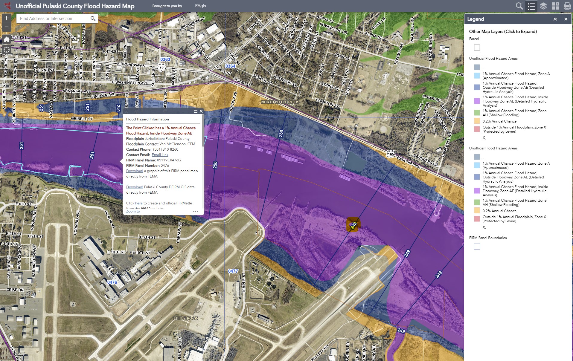
On this map high risk areas, identified as Special Flood Hazard Area (SFHA) are shown by dark blue or purple shadings.
- Purple areas mark the regulatory floodway, the channel of a flooding source (rivers, streams) and the immediately adjacent land areas where the risk of flooding is the highest. This is the most hazardous part of the floodplain, characterized by high-velocity flows. These areas must remain unobstructed to allow for floodwater to be carried downstream without causing potential damage to life and property. Development in the floodway is heavily restricted by FEMA regulations and city codes.
- Dark blue areas designate floodplain areas, which encompass the area of floodways. These areas naturally susceptible of being inundated during flood events, act as “sponges”, reducing flood speed and storing floodwaters.
- Base flood elevation (BFE) is the regulatory (computed) height of flood water determined by FEMA that floodwaters are expected to reach during a “base flood”, which is a flood event that has a 1% probability of occurring in any given year. The BFE is also the same as the 1% annual chance or the FEMA 100-year floodplain elevation. Base flood elevations are results of hydrologic and hydraulic analysis and signify the risk level of flooding that is an important regulatory measure for insurance and building regulations.
On the PAGIS map approximate Base Flood Elevations are indicated over the blue lines across the floodplain areas (circled in yellow).
Please keep in mind, these elevations only provide an approximate value for the BFE.
For official forms use the elevations derived from appropriate Flood Insurance Rate Maps (FIRMs) and Flood Insurance Studies (FISs) published by FEMA.
To obtain accurate elevation values applicants may be assisted by a Professional Surveyor (PS) or Professional Engineer (PE). - Flood Insurance Rate Maps (FIRMs) developed by FEMA and provide graphic information of the different flood risk areas within the City of Little Rock.
For accurate base flood elevation information FEMA has prepared detailed Flood Insurance Studies (FIS).
To view, print or order Flood Insurance Rate Maps (FIRMs) or Flood Insurance Studies (FIS) visit the FEMA Map Service Center.