


 Trash & Recycling
 Online Payments
 City Documents
 Parks
Parks
 Traffic Court
 E-NEWS
 EXPLORE
 NEWS
NEWS
UALR Trail Connector
The UALR Trail Connector project will better incorporate the University of Arkansas at Little Rock (UALR) campus to the larger community by creating a trail connecting it to neighborhoods west and south of campus and better connecting to all of Central Arkansas via an improved transit connection. It will connect the UALR campus and neighborhoods east of University Ave. to the Tri-Creek Greenway, contribute to the connection to the Southwest Trail, and make major improvements to the City's bike network (Fig. 1).
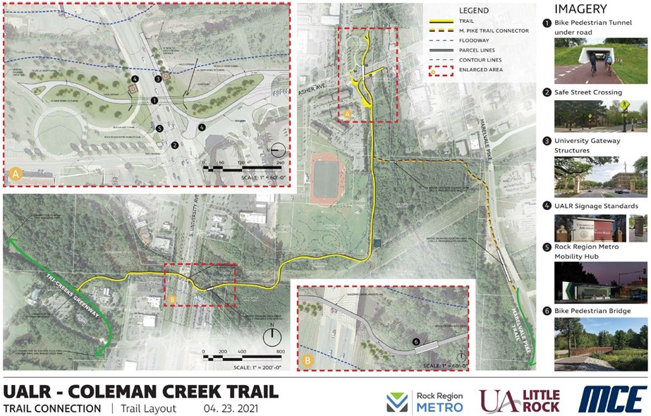
Figure 1. Concept map of the UALR Trail.
Community Access
UALR identifies as a "metropolitan research university". Rather than an isolated, independent campus, UALR seeks to integrate into our Little Rock community. Unfortunately, high capacity roads sever UALR from our community at its western border (University Ave., 31K vehicles per day) and its southern border (AR 5, 28K vehicles per day). The UALR Trail will create a stronger, safer connection to the surrounding community.
UALR Access
The UALR campus is located in an underinvested area of Little Rock. The UALR Trail would create better access from adjoining neighborhoods to UALR and increase opportunities for disadvantaged residents. Many UALR students who did not grow up in these neighborhoods still rent homes and apartments there to be close enough to UALR to walk or bike to campus and avoid the cost of car ownership. The UALR Trail would also provide safer access for these students. Finally, some students did not grow up and do not rent housing within walking or biking distance of campus but still are uninterested in or unable to own a car as a student. This project will include improved transit connection, facilitating car-optional UALR enrollment for student living farther away (Fig. 2).

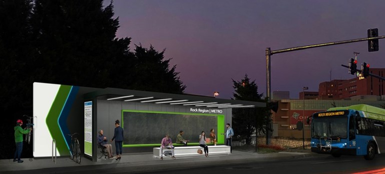
Figure 2. Rendering of the improved Rock Region Metro stop in the UALR Trail project.
Tri-Creek Greenway Access
The Tri-Creek Greenway provides a number of benefits to a disadvantaged area of Little Rock, but only for those who can get to it. Currently, the Tri-Creek Greenway will serve a transportation function for neighborhoods east of John Barrow Rd. and west of University Ave., who can access the trail walking and biking exclusively on and crossing only low-traffic, residential streets. The UALR Trail will connect an entirely new regions of Little Rock to the Tri-Creek Greenway (via the trail and residential streets, Fig. 3). Among the many benefits, the Tri-Creek Greenway provides access to several City parks. Growing research demonstrates the importance of spending time outdoors for the mental health of college students.
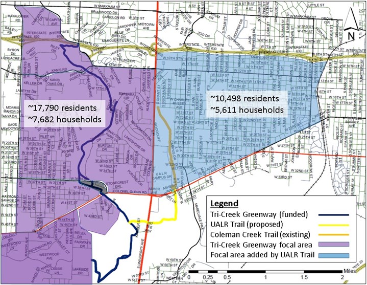
Figure 3. Map of the neighborhoods that would have access to the Tri-Creek Greenway via the UALR Trail (blue). We've defined the borders of this area by I-630 to the north and the Union Pacific tracks to the east, but see below.
Southwest Trail Access
The UALR Trail would be a portion of the Fourche Trail, which will connect the Tri-Creek Greenway to the Southwest Trail and thereby the Arkansas River Trail (Fig. 4). This is the only proposed trail connection between the Tri-Creek Greenway and the Southwest Trail or the Arkansas River Trail (the Rose Creek Trail has on-street components). A 100% off-street route will create an all ages and abilities connection between these regional bike trail systems which serve important transportation and recreation functions.
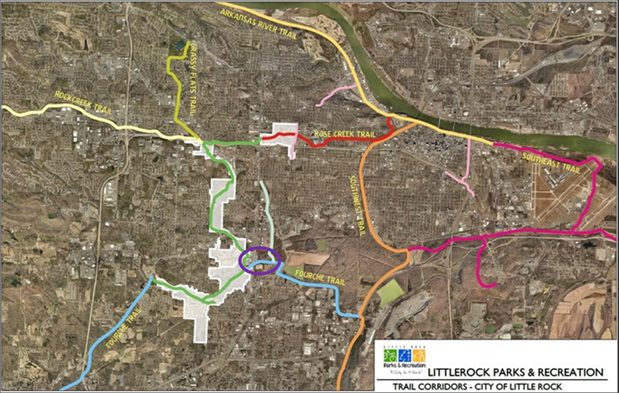
Figure 4. UALR Trail (purple circle) in the context of overall proposed and existing Little Rock trail connectivity.
Transportation Equity
Areas served by the UALR Trail are primarily low income and black. Improving bicycle and pedestrian access specifically for low income residents is important because car ownership may be unattainable. Low income residents may depend on walking and biking mobility directly or to access transit (i.e. the "last mile problem"). Not only is this a low income area of Little Rock, but it is also built as a particularly car-dependent area of Little Rock with few sidewalks, bike lanes, and off-street trails; the UALR Trail will be especially impactful for transportation equity in this part of Little Rock. Improving bicycle and pedestrian access specifically for black residents is important because this group is approximately three times more likely to be struck by a car when walking or biking in and three times more likely to be killed by a car while walking in the Little Rock metro area vs. white residents (Fig. 5). This pattern may be, in part, due to historic underinvestment in Little Rock's primarily black neighborhoods, a pattern Mayor Scott's administration is turning around by focusing on mobility and equity. The UALR Trail will improve transportation equity consistent with the City's new Mission and Vision.
MISSION
The City of Little Rock is dedicated to improving our residents’ quality of life by providing exceptional service in an efficient and equitable manner.
VISION
The City of Little Rock is a leading southern city – vibrant, safe, and innovative – that provides an excellent and sustainable quality of life where all families, individuals, and businesses can thrive.
Bike Network
The City is is constructing a city-wide bike network. The UALR Trail creates important no-stress University and Asher crossings for the network (Fig. 4, yellow line) and recruits an existing shared-use trail through the UALR campus for the network (Fig. 5, orange line). Tri-Creek Greenway Phase 3 will create a sharrow connection on low-stress residential streets between the Coleman Creek Trail and the intersection of Jackson / Jonesboro / 12th Street (Fig. 5, salmon line). From there, the 12th Street bike lanes connect east to the Arkansas Children's Hospital campus (Fig. 5, purple line). The City is actively seeking a bicycle connection on/along Jonesboro between 12th and Zoo Dr. (Fig. 5, red circle). This will connect to existing bike lanes on Zoo Dr., Fair Park Blvd., and Van Buren St. This will connect to the Kavanaugh bicycle corridor (sharrows and bike lanes) connecting Stifft Station, Hillcrest, and the Heights. A shared use trail in Allsopp Park and Cedar Hill Rd. bike lanes we have committed to install (Fig. 5, red dashed line) connects to the Arkansas River Trail and downtown Little Rock.
All of this is to say that the UALR Trail connects the Tri-Creek Greenway to the larger bike network and makes it much more relevant for regional transportation. The UALR Trail is key to connecting southwest Little Rock to job and entertainment opportunities downtown.
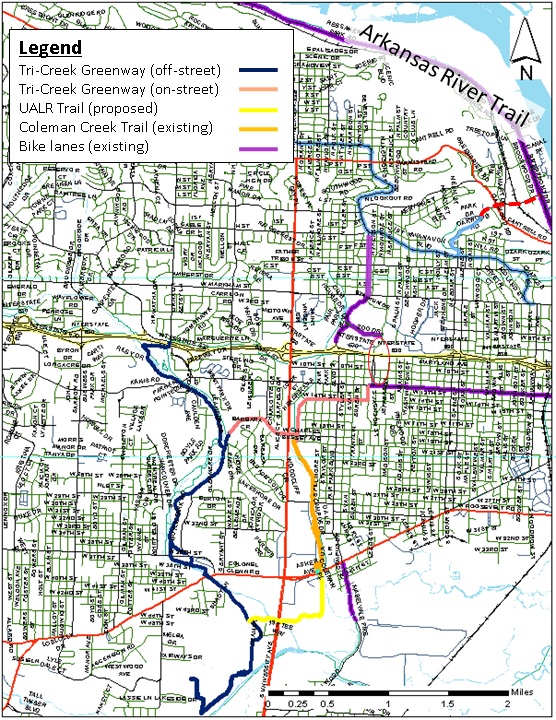
Figure 5. Map showing the larger bike network ramifications of the UALR Trail. Note that the 12th Street bike lanes (purple horizontal line) carry the network across the Union Pacific tracks and farther east than the UALR Trail Focal Area. Also note that, with a connection we are actively seeking funding for at Jonesboro (red circle), there is a fairly low-stress on-street route to the Arkansas River Trail.
