


 Trash & Recycling
 Online Payments
 City Documents
 Parks
Parks
 Traffic Court
 E-NEWS
 EXPLORE
 NEWS
NEWS
Jonesboro Children's Trail Phases 1-3
This page provides details on Phases 1-3 of the Jonesboro Children's Trail. At the time of this writing, these three phases are partially or fully funded but not yet constructed.
Overview
We will repurpose the western fork of Jonesboro Dr. from 12th St. to the split just south of I-630 for bikes and pedestrians only (Fig. 1). The corridor will continue a physically separated sidepath over the Jonesboro overpass and on the left side of Monroe St. to the bike lanes on Zoo Dr. (Fig. 1). More details below.
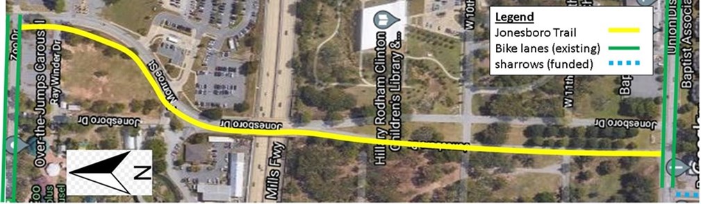
Figure 1. The Jonesboro Children's Trail Phases 1-3 will create an all ages and abilities sidepath from 12th St. to Zoo Dr.
12th Street Entrance
Phase One (Partially Funded 2021): The Jonesboro Children's Trail from 12th Street to the overpass was generously funded through a Metroplan Surface Transportation Block Grant. This project was funded, but not fully funded. Not all of the placemaking features in Figure 2, e.g. the gateway and other placemaking features, but the corridor will be safe and functional.
West Fork: The west fork will look completely different. Curb and gutter will replace the current entrance, physically barring vehicles from entry (Fig. 2). An arch will create a gateway to the Children's Zone (Fig. 2).
East Fork: The east fork will now accommodate two-way vehicular traffic.
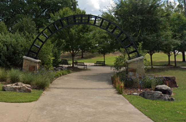
Figure 2. This is a photo of the gate to War Memorial Stadium on the southeast corner of Markham and Fair Park. This same design concept will be scaled up for the 12th St. entrance to the Jonesboro Children's Trail (not yet funded).
12th St. to Overpass
Phase One (Partially Funded 2021): The Jonesboro Children's Trail from 12th Street to the overpass was generously funded through a Metroplan Surface Transportation Block Grant. This project was funded, but not fully funded. Not all of the placemaking features in Figure 3, e.g. the planters, the different colored bricks, and other placemaking features, but the corridor will be safe and functional. All features in Figure 6 will be included to make the corridor safe and functional.
The street will be repurposed for a bicycle and pedestrian path (Fig. 3). We'll put in lighting to make the corridor safer and more comfortable. Other placemaking elements may also be added. A safe connection between the Jonesboro Children's Trail and the Children's Library will be a point of emphasis (Fig. 4).
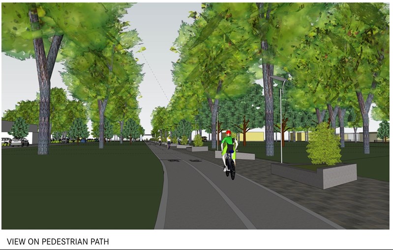
Figure 3. Lighting and other elements between 12th Street and the overpass will help create a comfortable corridor (image from Polk Stanley Wilcox).
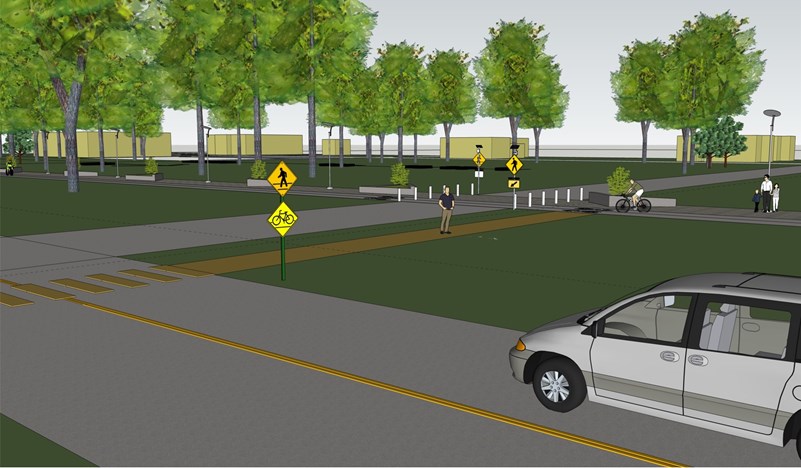
Figure 4. Connecting the Jonesboro Children's Trail to the Children's Library is central to the project purpose (image from Polk Stanley Wilcox).
I-630 Overpass
Phase One (Partially Funded 2021): The Jonesboro Children's Trail from 12th Street to the overpass was generously funded through a Metroplan Surface Transportation Block Grant. This project was funded, but not fully funded. Not all of the placemaking features in Figures 5-7 will be included, but the corridor will be safe and functional.
Placemaking elements on the overpass will serve trail users but will also advertise the City of Little Rock and the amenities in War Memorial Park (Figs. 5-7).
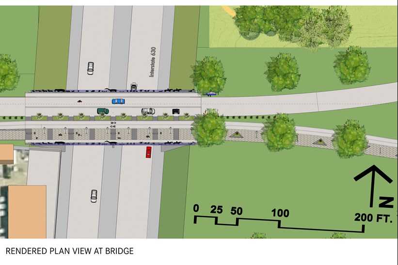
Figure 5. Aerial concept of the Jonesboro Children's Trail along the I-630 overpass (image from Polk Stanley Wilcox).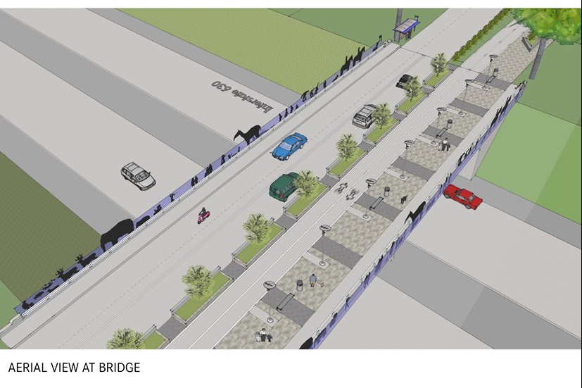
Figure 6. 3-D aerial concept of the Jonesboro Children's Trail along the I-630 overpass (image from Polk Stanley Wilcox).
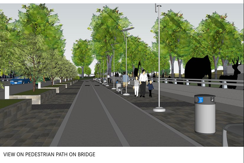
Figure 7. 3-D concept of the Jonesboro Children's Trail on the I-630 overpass (image from Polk Stanley Wilcox).
Monroe Street Sidepath
Phase Two (Fully Funded 2022): The Jonesboro Children's Trail from the overpass to Zoo Drive was fully funded through a Metroplan Transportation Alternatives Program grant.
Placemaking elements on the overpass will serve trail users but will also advertise the City of Little Rock and the amenities in War Memorial Park (Figs. 8-10). A tree canopy will help keep sidepath users safe and also decrease the heat island effect in Little Rock.
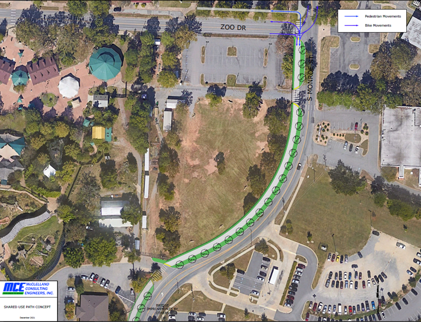
Figure 8. An aerial view of the proposed sidepath along Monroe St. from the I-630 overpass to Zoo Dr. (image from McClelland Engineering).
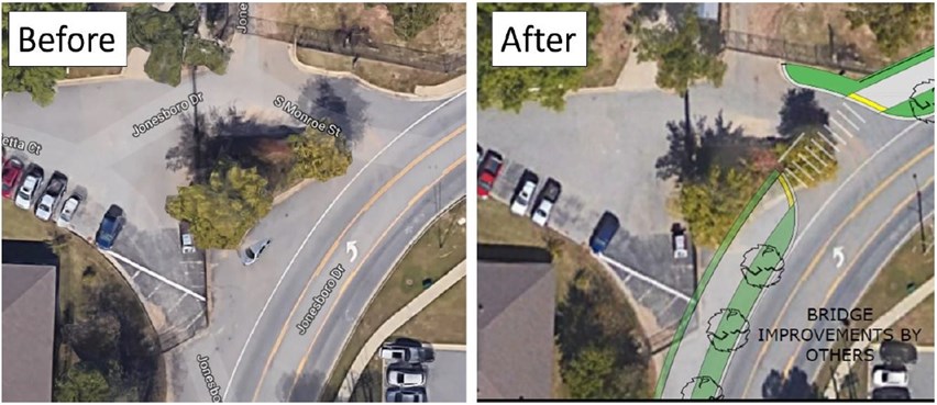
Figure 9. An aerial view of the proposed intersection treatment for the zoo staff entrance.
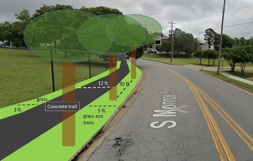
Figure 10. A cross-section of the proposed sidepath along Monroe St. between the I-630 overpass and Zoo Dr.
12th Street Crossing
Phase Three (Partially Funded 2022): The City of Little Rock applied for Jonesboro Children's Trail Phase Three funding from the overpass to Zoo Drive through the Arkansas Department of Transportation's Transportation Alternatives Program. This application was funded, but not fully funded. All 12th Street crossing elements will be included in the project, but the City will have to seek additional funding to create project elements south of 12th Street.
As appealing a facility as Phases 1 and 2 will create, it will have limited utility without improvements to crossing 12th Street. A main purpose of the Jonesboro Children's Trail is to connect underserved residents south of 12th Street to the CALS Children's Library and other War Memorial Park amenities. Another core goal is creating a safe connection between the on-street bike facilities of the Tri-Creek Greenway, ending at Jackson and 12th Street, both to the 12th Street bike lanes going east and to the Jonesboro Children's Trail going north. As it exists, few people would choose to cross 12th Street by walking or biking in this area and few would choose to walk two blocks east to the existing HAWK signal (Fig. 11).
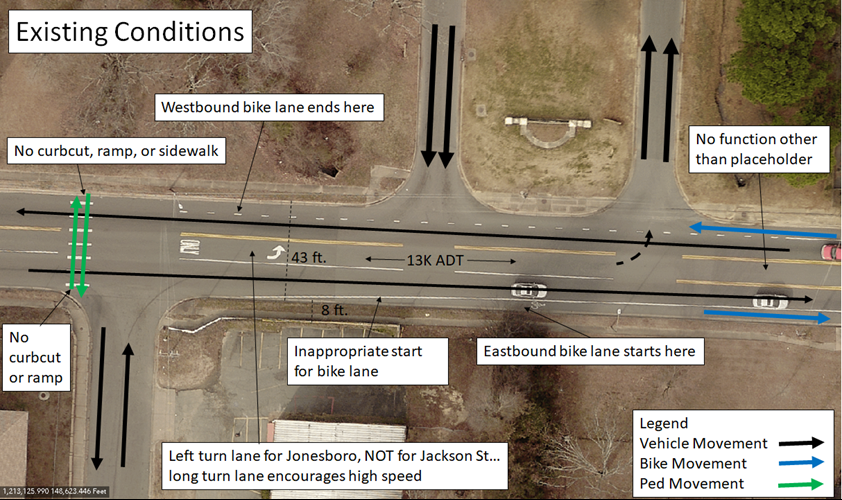
Figure 11. Existing conditions make crossing 12th Street uncomfortable and dangerous.
ARDOT TAP funding will allow us to move an underutilized HAWK signal just west of 12th and Madison Streets to this crossing (Fig. 12). We would incorporate several traffic calming measures to slow traffic and increase signal compliance including stamped concrete, crosswalk overhead lighting, advance stop bars, and a lateral shift in travel lanes (Fig. 13). We will change 12th Street geometry slightly north to facilitate a sidepath immediately south of 12th St. between Jackson St. and the crosswalk and allow space for a pedestrian refuge island (Fig. 13-17). A raised crosswalk across Jonesboro a car length from 12th St. will calm traffic and allow a car to cross the BikePed facility before waiting for a break in traffic at 12th Street (Figs. 14-15).
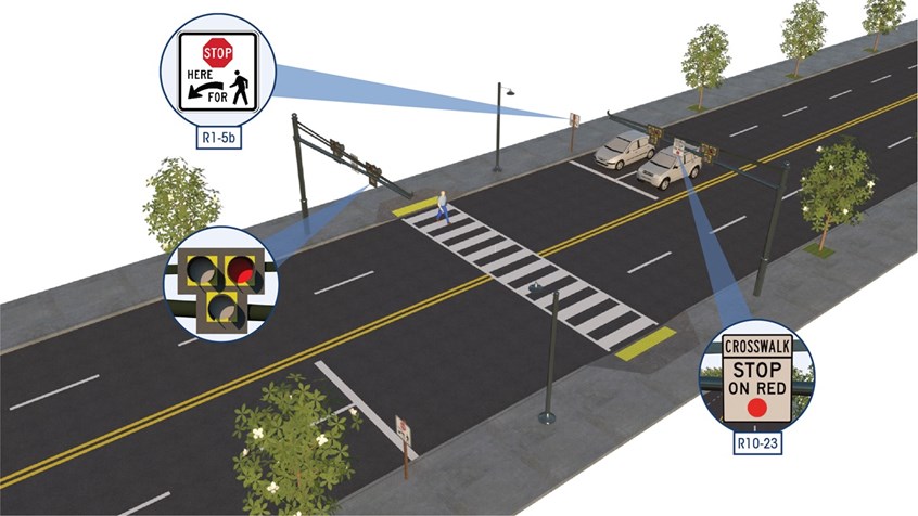
Figure 12. In order to create the safest crossing possible, the City is going to move an underused HAWK crossing just west of the 12th Street and Madison Street to use for this crossing between Jonesboro and Jackson Streets.
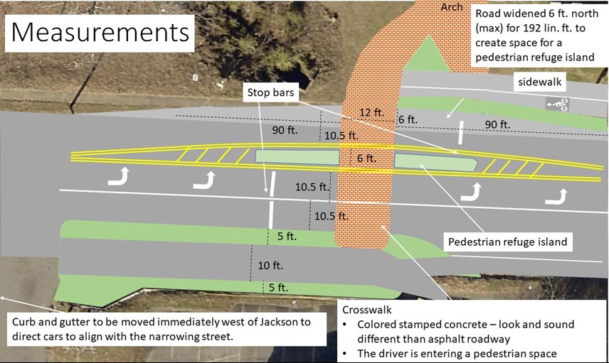
Figure 13. This is an aerial concept drawing of the 12th Street crosswalk. Note the sidepath on the south side, the space for which will be created by moving curb and gutter into the existing 43 ft. wide street corridor.
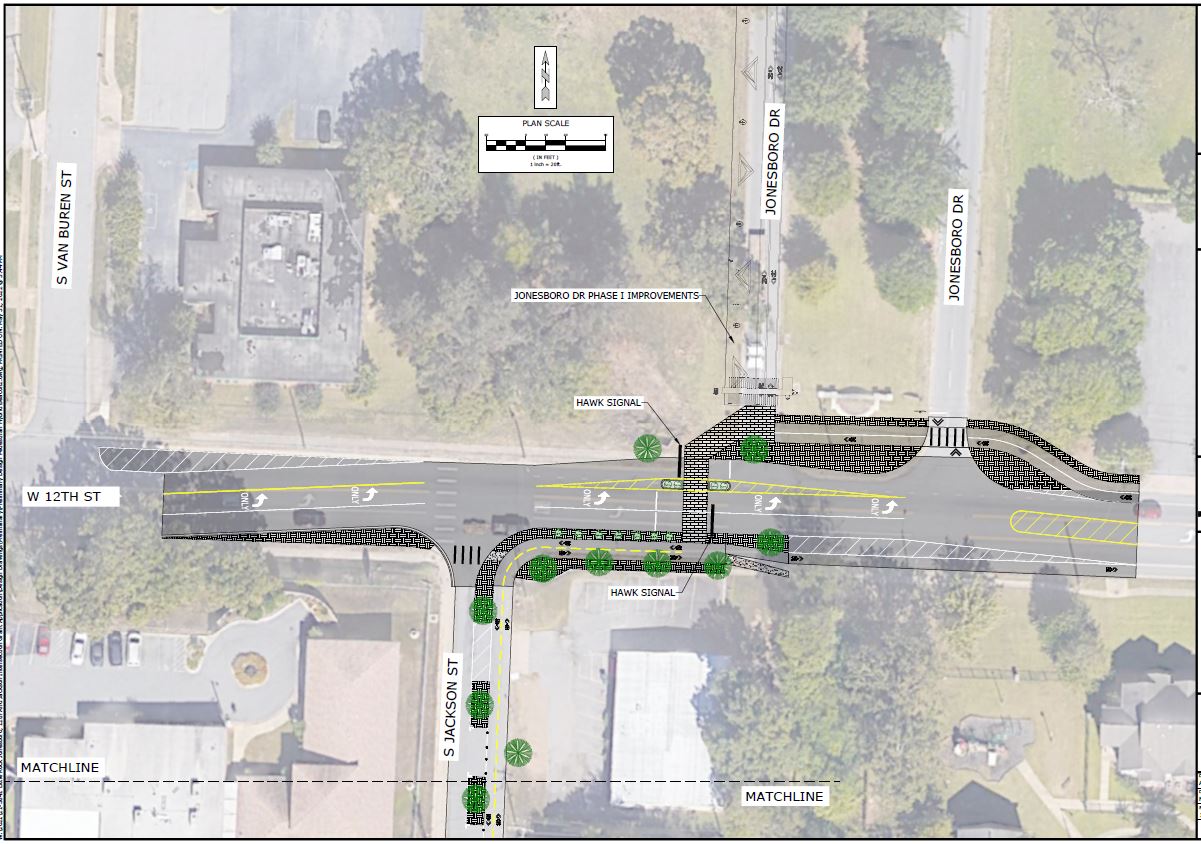
Figure 14. This concept map, created by McClelland Engineering, shows how BikePed facilities would cross Jonesboro St., 12th St., run along the south side of 12th St. (sidepath), and run down a protected shared use facility along Jackson St.
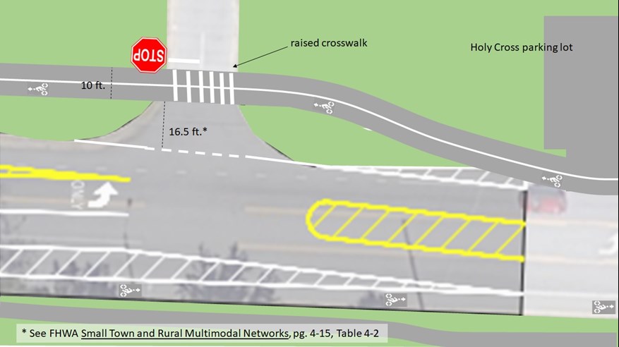
Figure 15. This concept map shows how the 12th Street sidewalks and the westbound bike lane would function at Jonesboro.
Canopy trees will be planted just north of 12th Street and along the 12th Street sidepath; these canopy trees will eventually create a closed canopy. When funding allows, additional canopy trees will be planted along Jackson St. between 12th and 14th Street. Arboring will reduce heat island effects, create shade that will make the facility more comfortable, and pull the park aesthetic across 12th St. to bridge the divide it creates between park amenities and an underserved community. Bushes will be used in landscaping where sightlines between cars and bikes are important. Landscaping will also alert 12th Street drivers that this is a shared space with people on bikes and walking(Figs. 16-17).
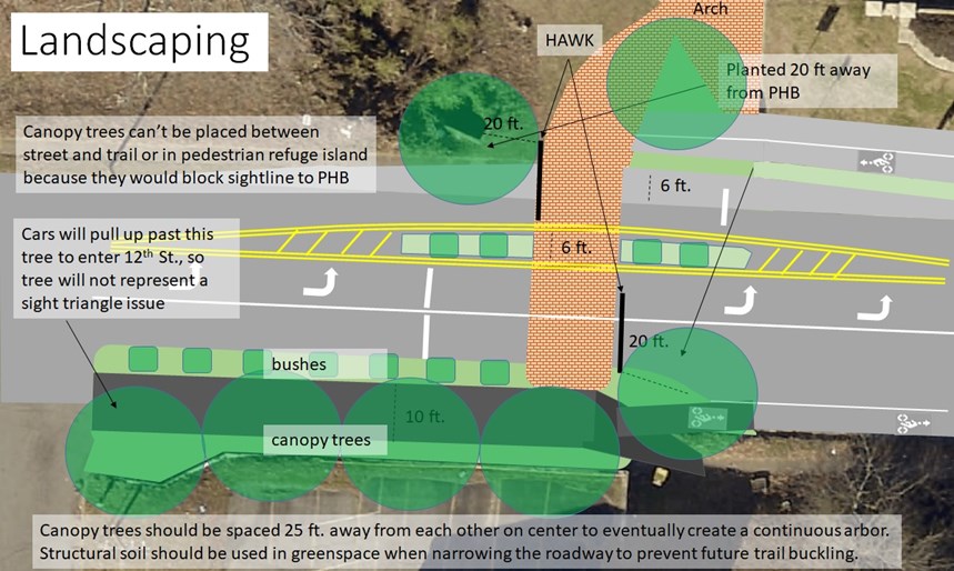
Figure 16. Canopy trees and other landscaping will be important for traffic calming and trail user comfort.
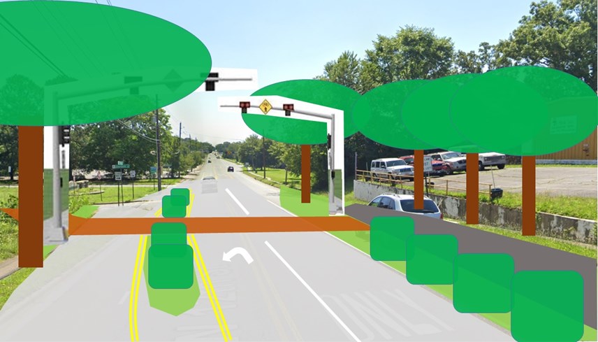
Figure 17. 12th Street crossing with landscaping in a street view. Note how the trees in back of the HAWK signals serve to frame the signals by reducing visual clutter behind them.
Future Phase: Jackson St. will be one-way north between 12th and 14th Street to allow the left turn lane onto Jonesboro to continue west past Jackson St. to facilitate morning rush hour traffic stacking. This will also create space for a 10 ft. wide sidepath on the east side of Jackson St. between 12th St. and 14th St. (Fig. 20). Physical separation between the sidepath and the travel lane will be created by greenspaces and parking stops. Eight parallel parking spots will be retained on Jackson St. between 12th St.and 14th St., far exceeding current parking demand. Southbound sidepath users must stop and yield to conflicting traffic at Jackson and 14th. This was planned for Phase 3 but not funded.
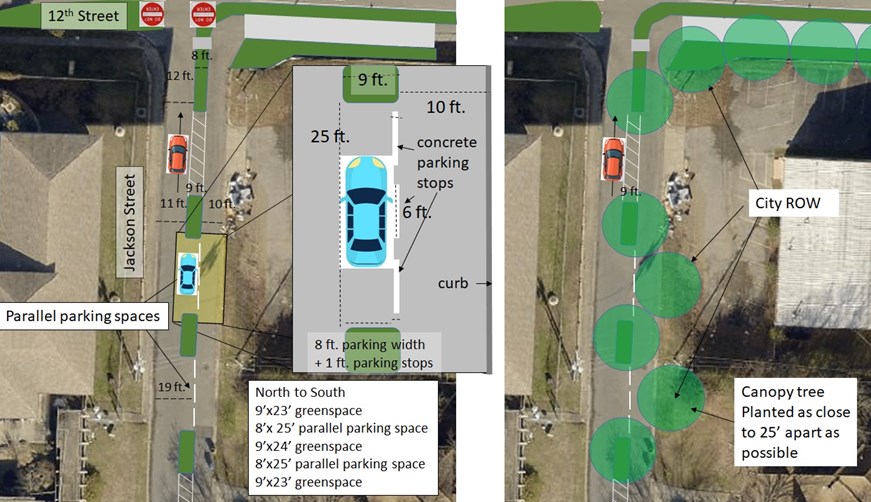
Figure 20. Aerial concept drawing for part of the Jackson Street sidepath.
Community Support
Successful funding of Phases 1-3 was the result of grassroots efforts. The Children’s Library was concerned about safe and equitable access; Jonesboro has no sidewalks and speeding traffic and 12th St. is a high traffic volume/speed street (Fig. 21). CALS partnered with CLR Parks and secured a Safe Routes to Parks grant. They created a coalition, collected community input, created a Pop Up demonstration of BikePed facilities on Jonesboro, and hired Polk Stanley Wilcox/McClelland Engineering to lay groundwork for this application.
The CALS 2020 annual report summarized the project in this way:
"With support from a Safe Routes to Parks Activating Communities grant and technical assistance from the Safe Routes Partnership, the Central Arkansas Library System (CALS) and Little Rock Parks and Recreation partnered to overcome racial and physical division to reconnect the Children’s Library neighborhood, a primarily Black neighborhood, with War Memorial Park."
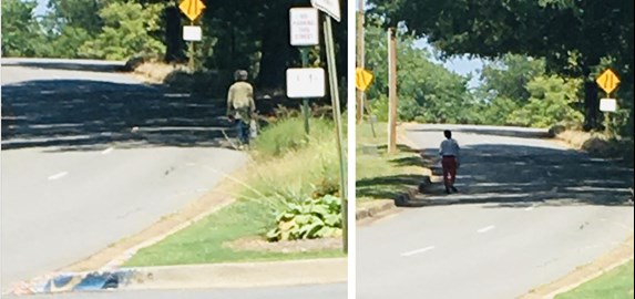
Figure 21. For those who are familiar with how fast traffic currently moves on Jonesboro, these pictures are scary. Photos by Katie Helms, Saturday September 17, 2022 (2022 BikePed Count).
