


 Trash & Recycling
 Online Payments
 City Documents
 Parks
Parks
 Traffic Court
 E-NEWS
 EXPLORE
 NEWS
NEWS
Frequently Asked Questions / Comments
Community Engagement
The City met with the Hillcrest Residents Association, the Hillcrest Merchants Association, twice sent out individual postal mail notices of the project to all Kavanaugh-addressed residences and business affected, twice made announcements in the Arkansas Democrat Gazette, twice published the project and how to comment on the City calendar, held a (virtual) public meeting (June 22, 2021), discussed operational concerns with the Hillcrest Farmer’s Market and the Pulaski Heights Baptist Church, held an in-person public meeting on August 26, 2021, accepted public comments through email, social media, and a web portal and will continue accepting public comments through September 9, 2021.
The City has since met twice with a subset of the Hillcrest Residents Association to discuss the project and has regularly discussed the project with the City's citizen-advisory board, the Active Transportation Advisory Committee and the Sustainability Commission.
The majority of compiled public comments to date has been positive, but concerns have also been expressed. The City has worked with the substance of those concerns and modified the project where possible to mitigate concerns. We are listening and responding to your questions and concerns. Here are some of the questions and comments we've gotten about the project. They have been paraphrased for brevity/clarity/aggregation.
Question #1 - Parking
"Will there be enough parking?" Jessica B., Jill B., Pat F., Jessica C., Linda C.
"..even though a parking study has been conducted, it only shows a brief moment in time and may not reflect true usage." HRA Letter, April 2022
Currently, parking is typically unrestricted on either side of Kavanaugh, but it is not heavily used. Trading parking on the north side of the street to create a stronger bicycle corridor would not decrease parking capacity below current, unrestricted parking use for any block, day or night.
The parking study considers parking usage for every block for a 1.1 mile stretch at 70 different time points over 14 years (though the magic of Google Streetview) day and night on all seven days a week. It likely represents the most exhaustive parking study ever conducted on a Little Rock corridor. For the great majority of blocks, new parking capacity does not approach current use (Figs. 1 and 2). For the majority of blocks, the range of parking use never exceeded capacity with bike lanes in any one of 70 observations.
There is actually a more definitive method we can use to answer the question "Is the collected data sufficient to say, definitively, that parking demand does not exceed new capacity with bike lanes?" A one-tailed, one sample t-test answers the question whether a set of collected data (block by block parking observations) is significantly different from a stated mean (new block-by-block parking capacity with bike lanes). This statistic takes into account the number of observations collected (as well as their values and variation).
| One Sample T-Test: Daytime | |||||||||
| Block | Average | Standard Deviation | Number of Observations | Standard Error | Degrees of Freedom | Parking Capacity | T-Statistic | T critical 0.0005 | P-value |
| 1 | 6.923076923 | 1.95185 | 39 | 0.312546 | 38 | 9 | -6.645174354 | 3.307 | <0.0005 |
| 2 | 5.820512821 | 2.382743 | 39 | 0.381544 | 38 | 13 | -18.81692162 | 3.307 | <0.0005 |
| 3 | 1.625 | 1.169867 | 40 | 0.184972 | 39 | 12 | -56.08948605 | 3.307 | <0.0005 |
| 4 | 5.1 | 1.984556 | 40 | 0.313786 | 39 | 16 | -34.73707044 | 3.307 | <0.0005 |
| 5 | 5.55 | 2.087202 | 40 | 0.330016 | 39 | 16 | -31.66517556 | 3.307 | <0.0005 |
| 6 | 0.333333333 | 0.662266 | 39 | 0.106047 | 38 | 11 | -100.5838953 | 3.307 | <0.0005 |
| 7 | 1.487179487 | 1.097168 | 39 | 0.175688 | 38 | 14 | -71.22200496 | 3.307 | <0.0005 |
| 8 | 3.538461538 | 1.429872 | 39 | 0.228963 | 38 | 12 | -36.95595452 | 3.307 | <0.0005 |
| 9 | 4.333333333 | 1.825742 | 39 | 0.292353 | 38 | 12 | -26.22403478 | 3.307 | <0.0005 |
| 10 | 1.512820513 | 0.942332 | 39 | 0.150894 | 38 | 10 | -56.24602654 | 3.307 | <0.0005 |
| 11 | 4.282051282 | 1.296731 | 39 | 0.207643 | 38 | 8 | -17.90547232 | 3.307 | <0.0005 |
| 12 | 1.8 | 1.304823 | 40 | 0.206311 | 39 | 6 | -20.35764561 | 3.307 | <0.0005 |
| 13 | 1.475 | 2.908762 | 40 | 0.459916 | 39 | 15 | -29.40756423 | 3.307 | <0.0005 |
| 14 | 0.794871795 | 1.435994 | 39 | 0.229943 | 38 | 9 | -35.68330743 | 3.307 | <0.0005 |
| 15 | 1.780487805 | 1.255233 | 41 | 0.196034 | 40 | 6 | -21.52434003 | 3.307 | <0.0005 |
| 16 | 11.55 | 2.308846 | 40 | 0.365061 | 39 | 23 | -31.3646569 | 3.307 | <0.0005 |
| 17 | 9.025641026 | 4.613979 | 39 | 0.738828 | 38 | 21 | -16.20723753 | 3.307 | <0.0005 |
| 18 | 2.435897436 | 1.698217 | 39 | 0.271932 | 38 | 11 | -31.49350566 | 3.307 | <0.0005 |
| 19 | 0.894736842 | 0.923843 | 38 | 0.149867 | 37 | 3 | -14.04753834 | 3.307 | <0.0005 |
This analysis shows that there is (much) less than 0.05% chance that daytime parking demand actually exceeds new parking capacity with bike lanes for any block, but the number of observations failed to detect that. This is the limit of most t-tables.
| One Sample T-Test: Nighttime | |||||||||
| Block | Average | Standard Deviation | Number of Observations | Standard Error | Degrees of Freedom | Parking Capacity | T-Statistic | T critical 0.0005 | P-value |
| 1 | 8.533333 | 1.73669 | 30 | 0.317075 | 29 | 9 | -1.471787531 | 3.385 | 0.05-0.10 |
| 2 | 8.933333 | 3.372642 | 30 | 0.615757 | 29 | 13 | -6.604333356 | 3.385 | <0.0005 |
| 3 | 1.4 | 1.162637 | 30 | 0.212267 | 29 | 12 | -49.93700113 | 3.385 | <0.0005 |
| 4 | 7.666667 | 1.748563 | 30 | 0.319242 | 29 | 16 | -26.10346677 | 3.385 | <0.0005 |
| 5 | 8.666667 | 1.625939 | 30 | 0.296855 | 29 | 16 | -24.70345866 | 3.385 | <0.0005 |
| 6 | 0.266667 | 0.52083 | 30 | 0.09509 | 29 | 11 | -112.8752874 | 3.385 | <0.0005 |
| 7 | 1.9 | 0.922889 | 30 | 0.168496 | 29 | 14 | -71.81191696 | 3.385 | <0.0005 |
| 8 | 3.633333 | 1.519604 | 30 | 0.27744 | 29 | 12 | -30.15662615 | 3.385 | <0.0005 |
| 9 | 5.866667 | 1.431983 | 30 | 0.261443 | 29 | 12 | -23.45953486 | 3.385 | <0.0005 |
| 10 | 2.366667 | 1.129032 | 30 | 0.206132 | 29 | 10 | -37.03127867 | 3.385 | <0.0005 |
| 11 | 4.5 | 1.54808 | 30 | 0.282639 | 29 | 8 | -12.38326789 | 3.385 | <0.0005 |
| 12 | 2.7 | 1.803254 | 30 | 0.329228 | 29 | 6 | -10.02346134 | 3.385 | <0.0005 |
| 13 | 0.733333 | 2.227312 | 30 | 0.40665 | 29 | 15 | -35.08343029 | 3.385 | <0.0005 |
| 14 | 0.533333 | 1.136642 | 30 | 0.207521 | 29 | 9 | -40.7990039 | 3.385 | <0.0005 |
| 15 | 2.266667 | 1.484014 | 30 | 0.270943 | 29 | 6 | -13.77904978 | 3.385 | <0.0005 |
| 16 | 14.7 | 1.950243 | 30 | 0.356064 | 29 | 23 | -23.31041269 | 3.385 | <0.0005 |
| 17 | 2.933333 | 4.025208 | 30 | 0.734899 | 29 | 21 | -24.58387505 | 3.385 | <0.0005 |
| 18 | 3.366667 | 2.025413 | 30 | 0.369788 | 29 | 11 | -20.64244838 | 3.385 | <0.0005 |
| 19 | 1.9 | 0.48066 | 30 | 0.087756 | 29 | 3 | -12.53472788 | 3.385 | <0.0005 |
This analysis shows that there is (much) less than 0.05% chance that night time parking demand actually exceeds new parking capacity with bike lanes for any block except Block 1, but the number of observations failed to detect that. For Block 1 (between Markham and Fairfax Ave.), nighttime parking demand has between a 5% - 10% chance of exceeding new parking capacity with bike lanes. Parking needs for Block 1 should be carefully considered.
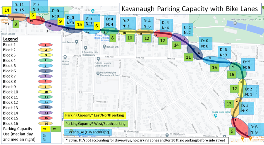
Figure 1. Block by block parking capacities with bike lanes (yellow and green) and current use on both sides of street (blue) day and night.
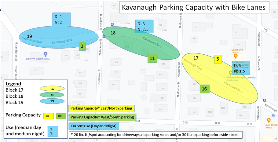
Figure 2. Block by block parking capacities with bike lanes (yellow and green) and current use on both sides of street (blue) day and night.
Question #2 - Physical Protection
"Will be buffers be concrete curbs or just paint? Concrete curbs are better." Courtney C., Matthew B.
It’s true that separated bike lanes (physically protected) are safer, encourage more ridership, and are the FHWA-recommended facility type for this street’s traffic volume and speed limit (Figs. 3-4). The City's resurfacing budget only allowed for buffered bike lanes on both sides of Kavanaugh, but through funding from People for Bikes, we are able to modify the project to create a physical protection for the bike lanes on the side without parallel parking (Figs. 5-6). See "Protected Bike Lane Design" for more information.
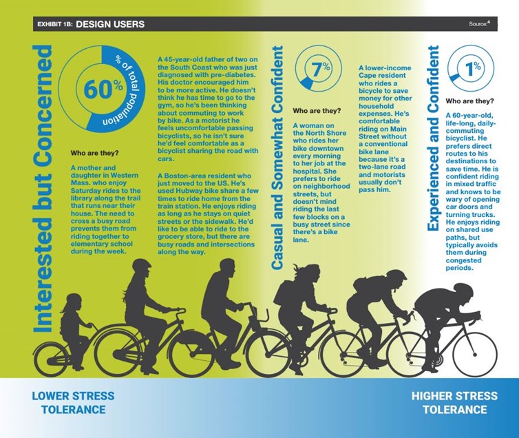
Figure 3. A small percentage of the population is willing to bike on a street with no separation from vehicular traffic, but a much larger percentage would bike if that separation existed (pg. 5).

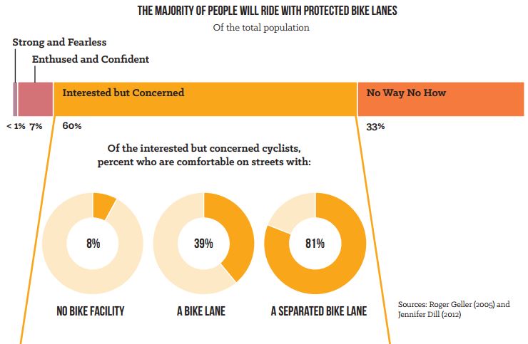
Figure 4. When potential bicycle riders are categorized by their stress tolerance, the largest pool of people fall into the "Interested but Concerned" category (Fig. 11). Designing facilities for this group maximizes the impact on ridership. Quality of the bike facility is critically important in its efficacy for this group and overall. A separated bike lane has a much greater impact on ridership than a standard bike lane Figure from NACTO report, pg. 6.
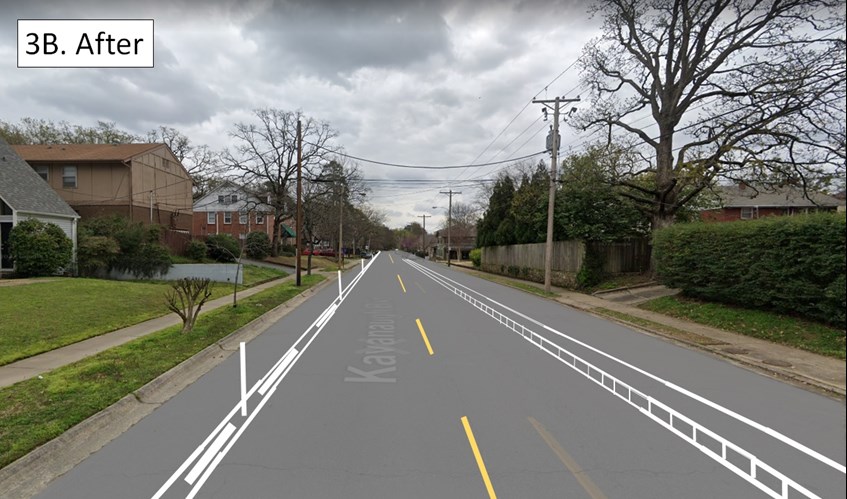
Figure 5. Kavanaugh with physically protected bike lane. See also.
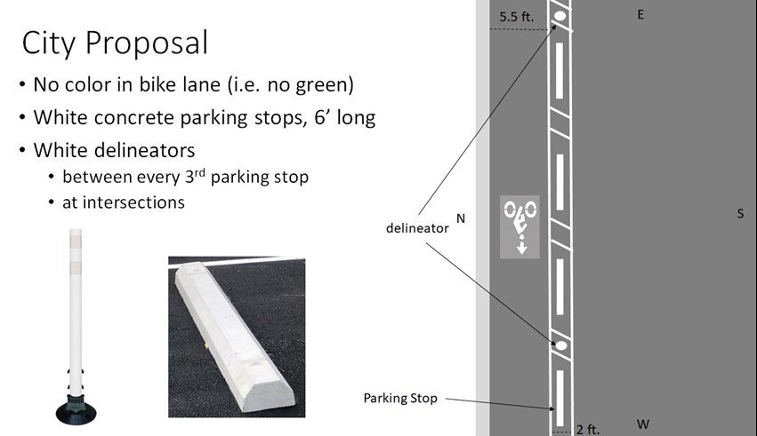
Figure 6. Elements of the physically protected bike lane proposed by the City. See also.
Question #3 - Side Street Parking
"How will parking capacity on side streets be affected?" Bruce S.
Side street parking use was not quantified in the parking study, but both day and night anecdotal observations while doing the Kavanaugh parking study show capacity exceeds current demand there as well. There could be some intermittent parking spillover onto side streets, but this should not be dramatic or typical since Kavanaugh’s parking capacity with bike lanes would remain above current demand for all blocks.
Question #4 - Parking-Protected Bike Lane
"Why not have a parking-protected bike lane?" Courtney C., Katharine H., Jane A., Heather D.
Definition: A parking-protected bike lane puts the lane of parked cars in between the travel lane and the bike lane, thereby creating a physical barrier (row of parked cars) in between bikes and cars.
We considered a parking-protected bike lane, but they require a no parking zones for driveway and side street access to preserve sightlines between bikes in the lane and motorists (e.g. Fig. 7). Because of the frequency of driveways and side streets, no parking zones would reduce parking capacity below current demand for some blocks.
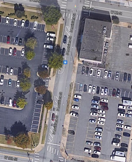
Figure 7. Note that, with a parking protected bike lane and one major parking lot access point midblock, that Louisiana St. between 8th and 9th Streets has only five parallel parking spots because of the no parking buffers that must be created in order for people driving to see people biking and visa versa. Kavanaugh blocks often have more than one property access point and high enough parking demand that this type of facility would not allow the street to meet current parking demands.
Question #5 - Sidepath
"I like the idea of bike lanes on Kavanaugh, but why not create a shared use (walking and biking) sidepath on the north side of Kavanaugh instead?" James W.
This recommendation is consistent with FHWA guidance that a street with Kavanaugh's characteristics should either have physically protected bike lanes or a sidepath. There would certainly be benefits to a sidepath or even a two-way cycletrack over the proposed one-way bike lane design. First, both directions of bicycle traffic would be physically protected, making users feel more comfortable, encouraging ridership, and thereby encouraging safety. Second, people on bikes traveling east/south would not be between moving vehicular traffic and parallel parked cars (risk of dooring).
The main reason that the City is not proposing a sidepath at this time is budgetary. Kavanaugh is being resurfaced on the 2021 maintenance schedule. This process removes all existing striping. The difference in cost to restripe it as it exists now or with bike lanes is negligible. The City has applied for and received grant funding from People for Bikes to create a physical barrier to increase the safety of the facility, again costing the City no money. Creating a sidepath in this corridor, on the other hand, would have a significant financial cost. The curb would have to be moved and the sidepath would have to be built. That is outside of the scope of this resurfacing project.
That said, a sidepath is not outside of the realm of possibility eventually. McClelland Engineering created a rendering of what that might look like (Fig. 8). The best way to get grant funding for a sidepath (Fig. 8 Potential) would be to use our existing resources to create a two-way cycletrack on the north side of Kavanaugh (Fig. 8 After). This would place the vehicular centerline correctly for a sidepath and allow us to use our People for Bikes grant. This would also allow us discuss in our grant application how traffic flow has been proven to work with a longer-term pop-up and get letters of support from the Hillcrest Resident's Association and Hillcrest Merchant's Association to submit with the application.
The other concern about a sidepath is vehicular crossings. Kavanaugh has a high density of driveways and side streets. Drivers turning onto Kavanaugh or into driveways/side streets from Kavanaugh would be expected to yield to traffic in the cycletrack just as they would to vehicular traffic in Kavanaugh's travel lanes. Drivers entering the roadway are looking for traffic conflicts on the roadway but may not see conflicts on the sidepath (especially when bike traffic is coming from the "wrong" direction on a two-way facility). Sidepath crossings could be designed more deliberately than a two-way cycletrack, but this would continue to be disadvantage for the safety of this facility.
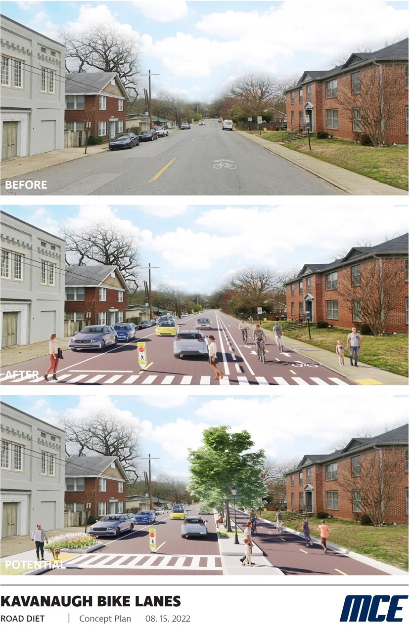
Figure 8. By installing a two-way cycletrack on the north side of Kavanaugh now, we could set the stage for a successful grant application for a sidepath.
Question #6 - Bike on Sidewalk
"Why can't people ride a bicycle on the sidewalk instead of creating bike lanes?" Jill B.
For some of Kavanaugh, this would be illegal, and for all of Kavanaugh, this would be unsafe for an adult riding a bike and for pedestrians on the sidewalk.
§ 32-494 – No person shall ride a bike upon a sidewalk in a business district (City of Little Rock Municipal Code)
Understand that an adult riding a bike is typically traveling ~7-20+ mph (depending on topography and fitness). Sidewalks are often uneven (i.e. tree roots pushing up sections) and incomplete, making them an unsafe facility for an adult on a bike even without anyone else around. Sidewalks are designed for pedestrian movement and so, if an adult riding a bike were to ride on the sidewalk, she would be sharing the ~5 ft. wide sidewalk with pedestrians. Minimum recommended width for a shared-use facility (i.e. paved trail) is 10 ft. wide; people walking and biking simply don't have enough room to share this space safely (Fig. 9).
Finally, and perhaps most importantly, sidewalks cross driveways and side streets. Drivers do not (and should not) expect a use conflict from bicycle traveling 7-20+ mph coming from the sidewalk. In practice, drivers coming from a driveway or side street will stop and wait for traffic to clear while their vehicle is blocking the sidewalk so that they can get a clearer view of Kavanaugh traffic. Car and bicycle operators cannot see one another to avoid a collision given the speed with which the bicycle travels.
Figure 9. Sidewalks aren't designed for bicycles. Especially in high pedestrian traffic areas like the Kavanaugh corridor, riding a bicycle on a sidewalk creates dangers for people walking and biking.
Question #7 - Parallel Park on South Side
"Could the parking be on the south/west side of the street instead?" Jessica B., Hannah V., Alexandra H., Tom C., Lou and Melinda T.
This was a comment/concern we received from several residents and, reviewing videos of parking use, where there was a preference for the north vs. the south side of the street, there was typically more parking on the south side (Figs. 6-7, Blocks 1, 2, 5, 18 and 19, but see Block 12). We therefore modified the project to reflect this community priority. Parking is now proposed to typically be on the south side of the street. Parking will transition to the north side in front of Allsopp Park because curb bump outs make this the only side parking can be retained and still allow bike lanes.
Question #8 - Traffic Speed / Calming
"Couldn't the speed limit be reduced to 25mph to make Kavanaugh safer for everyone?" Antoinette J.
"A major problem on Kavanaugh / in the city is speeding traffic. How would this project calm traffic?" Bruce S., Ed L., Jim M.
The Kavanaugh speed limit could, and perhaps should, be set to 25mph on Kavanaugh to better match the multi-modal, neighborhood character of the street. That said, in urban settings, drivers typically set their speeds not by the speed limit but by street design. To be effective at reducing average and 85th percentile speeds, a drop in speed limit would have to be coupled with changes in the street design, like the proposed protected bike lanes.
Narrowing lane widths is a proven traffic calming technique promoted by US DOT and FHWA. Highway lanes are 12 ft. wide in order to safely allow some lateral movement at highway speeds. However, when lanes are this wide or wider on city streets, it induces faster driving speed. Narrowing the lanes, and creating a visible space for bicycles, are both visual cues that this is a 30 mph street. The project also contains a lateral shift between Pine and Cedar. When the lateral shift is created with a design speed matching the speed limit of the street, as will be done here (30 mph), it serves as a proven traffic calming technique. Finally, bicycle and pedestrian placemaking through infrastructure, and the resulting increase in bicycle and pedestrian activity, will both serve to calm traffic.
Several comments have proposed increased traffic enforcement on Kavanaugh as a way to calm traffic. That could be an effective technique, but would be most effective when coupled with changes in street design. Otherwise enforcement and street design are working against one another. In any case, the design of this project cannot affect the amount of traffic enforcement on Kavanaugh. These are two related, but separate, questions.
Question #9 - Pedestrian Safety
"Could these changes make conditions more dangerous for pedestrians?" Bruce S.
"While we appreciate the idea of a more bikeable city, the HRA would like to see equal emphasis placed on walkability and pedestrian safety." HRA Letter, April 2022
This project would improve pedestrian safety on Kavanaugh in several important ways (Fig. 10). It would:
1) create a physical distance between the sidewalk and the vehicular travel lane where, in parts of the corridor, there is only a curb (Fig. 10).
1a) ~7 ft. wide distance on the side without parallel parked cars
1b) ~15 ft. wide distance on the side with parallel parked cars
2) create a physical protection between the sidewalk and the vehicular travel lane:
2a) on the side without parking via the bike lane's physical protection (parking stops)
2b) on the side with parking by doubling the density of the steel barrier (parallel parked cars) between the vehicular lane and sidewalk
3) Reduce vehicular speeds / calm traffic
4) Reduce effective crosswalk width (crossing pedestrian will be exposed to vehicular travel lanes for a 20 ft. walking distance instead of a 42 ft. wide crossing distance). Combined with slower traffic speeds, this will make Kavanaugh feel much safer to cross.
See also Benefits.
"YES to bike lanes on Kavanaugh! Like it or not, Kavanaugh is one of the most popular streets used by cyclists, runners and walkers in the city. Early in the morning, on most days, you would think some kind of running event was taking place from 5:30 a.m. until well after 8:00 a.m. I am one of those early morning users and I see it first hand." Emil M.
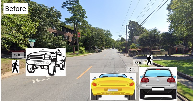
Figure 10. Google streetview illustrating how bike lanes protect pedestrians on sidewalks and parked cars. Again, no green would appear on the streets. Green is just used here to make it easier to see where the bike lanes are.
Comment #10 - Protect Parallel Parked Cars
"The real problem on Kavanaugh is cars going too fast and cars hitting Kavanaugh's parallel parked cars." Jim M. and Virtual Meeting
This is a criticism of how the street functions in its current design. This redesign should improve both of these concerns. First, narrowing the lane width and creating visual cues that this is a multimodal corridor should calm traffic (see also Questions 8 and 18). Second, this design will create a ~7 ft. buffer between moving cars and parked cars where now there is none (Fig. 10).
"...parked cars and the people exiting them would have more space separated from bike lanes and traffic" Lisa M.
Comment #11 - Parking and Businesses Between Pine and Oak
"Parking on the northside of Kavanaugh would be bad for our businesses and there won't be enough parking for our businesses between Pine and Oak" Jessica C., Linda C.
In part as a result of this input, the City modified the project, switching the parking to the south side of the street, as preferred by these businesses, so that patrons can park on the same side of the street as the businesses. Regarding the amount of available parking, the project will retain eight parallel parking spots between Pine and Oak, four between the Rock Region Metro stop and the alley and four between the garage access and the no parking sign before Oak. Repeated observations confirm that current use does not approach this capacity (Question #1, p <0.0005).
Typical, unrestricted parking demand is four cars during the day and four cars at night. 69 parking observations, day and night, weekday and weekend, show that these eight spots would not only meet average parking demand but also peak parking demand for this block. Interrupting the bike lane for this block would increase the overall stress of this corridor and is not warranted based on parking use.
Comment #12 - Hillcrest Square
"This project would remove necessary parking for Hillcrest Square." Nallery C.
While our data do not support this assertion, business hour peak parking demand can sometimes approach capacity, and parking demand functions like the business district for this block (Fig. 15). Also this block was originally proposed to be the start of the western edge of the bike lanes (so their start can be pushed back a bit and not interrupt a continuous corridor). Therefore, the City has modified the project to retain parking on both sides of the street directly in front of Hillcrest Square and start the bike lanes midblock (Fig. 11). This will allow a meaningful bicycle corridor between Van Buren and the Hillcrest Business District and narrow lanes up to the District to calm traffic immediately adjacent to the District.
Figure 11. This is the revised proposed lane configuration between Spruce and Pine. Parking is retained along the entire block on the south side and retained on the north side immediately in front of Hillcrest Square. Bike lanes start midblock and continue west.
Question #13 - Hillcrest Farmer's Market
"I'm for the bike lanes, if you can accommodate parking for the Hillcrest Farmer's Market. How would this project affect the Hillcrest Farmer's Market?" Kimberly G.
This is another example of the importance of community engagement on projects like this. The City worked directly with Hillcrest Farmer's Market and Pulaski Heights Baptist Church to better understand their needs for this space and accommodate those needs as best as possible with the project. From these conversations, we learned that they are not as concerned about parking capacity as they are with access to mobility-challenged patrons and parishioners. They were most concerned about losing the spaces directly in front of the church as originally proposed.
Based on their input, the City modified the project to transition a block east, between Cedar and Pine so that parking would be on the north (church) side for the farmer's market and church (Fig. 12). This block is currently used for parking, but typically only two cars during the day and three cars at night. Unlike most of the corridor, current parking demand is on the northside; this project modification will help this block function better for residents as well.
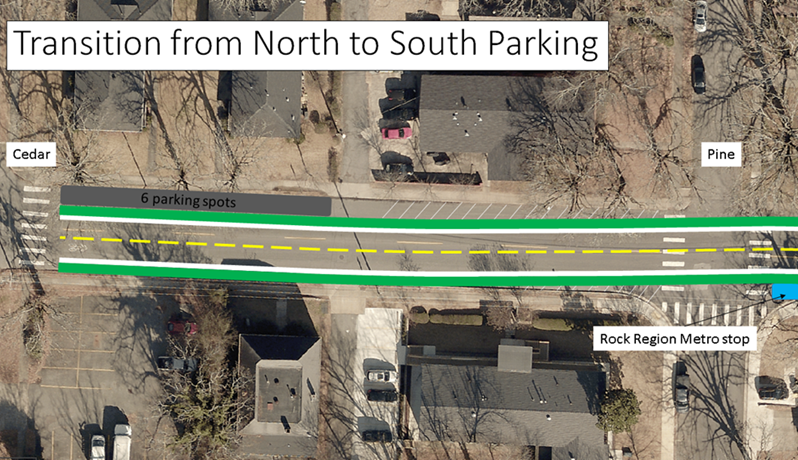
Figure 12. Transitioning parking between Pine and Cedar will make the street function better for the the Hillcrest Farmer's Market, Pulaski Heights Baptist Church, and the residents of the block between Pine and Cedar. Green paint/striping would not appear on the street; green is used here for illustration only.
Question #14 - Buffer Location
"On the side of the street with parking, couldn't you put the buffer between the row of parked cars and the bike lane to prevent “dooring”?" Virtual Public Meeting
The short answer is yes. There are two dangers that buffers could mitigate. A buffer between the travel lane and the bike lane (as proposed), a "travel side buffer", offers greater protection from a driver drifting into the bike lane, large mirrors on a vehicle, etc. A "parking side buffer" offers protection against dooring. These are both important concerns, but road width is insufficient to create both. Either is defensible; NACTO has design guidance for both (for travel side buffer bike lanes, NACTO recommends the bike lane be at least five feet wide to allow people to ride within the bike lane out of the door zone).
The City is currently proposing to install a "travel lane buffer" for three reasons. First, parallel parked cars on residential Kavanaugh have low turnover. While dooring is still an important concern, it is not as important as it would be if we were establishing these lanes in a business district with high parking turnover. Second, travel lane buffers may increase perceived safety more than a "parking side buffer" and therefore be more effective at increasing ridership; increasing ridership also increases actual safety). Third, given narrowing the travel lane to 10 ft. (Question #18), a travel side buffer would be an added safety measure for mirrors on large vehicles. If you prefer a "parking side buffer" instead, please submit comments reflecting that preference.
The City certainly understands this concern. Given that the buffer on the non-parking side will likely have a physical buffer, where road width is less constrained, we will likely keep that buffer at the NACTO-minimum 18 inches and increase the bike lane width on the parallel parking side of the street to allow people on bikes the space to ride farther from the line of parked cars.
Creating a two-way cycletrack on the north/east side of Kavanaugh would resolve this conflict.
Question #15 - Buffer Width
"Couldn't the buffer be wider?" Katharine H.
Ideally the buffer would be wider. Buffers will likely approach the 18 inch NACTO-recommended minimum width due to street width and the widths necessary for vehicular travel, parking, and bicycle travel. The City has attempted to optimize the street width available for the safety of people on bikes and all street users. If there were a two-way cycle track, the buffer could be wider (because only one wide buffer would be necessary rather than two narrow buffers) and if there were a sidepath, the buffer could be wider still (because we would use the existing sidewalk width as part of the sidepath, allowing more space in between the vehicular lane and sidepath).
Question #16 - Trash Pick-Up
"I am for the bike lanes, but how will you handle trash pick-up?" Maggie H.
Trash cans should be left on the curb (not in the bike lane). On the side with physical protection, both the City's trash truck arms and our contractor's recycling arms have a lateral extension of 9 ft., making it easy for them to pick up trash and recycle containers left on the curb (Fig. 13). On the parallel parking side, trash and recycle trucks will enter the bike lane to collect refuse as they would on any other street that allows parallel parking. If a person on a bike wishes to pass a truck in the bike lane, it is her responsibility to check for conflicting traffic and merge into the travel lane.
If a two-way cycletrack or sidepath were installed, trash pick-up would likely be facilitated with designated spaces within the buffer.
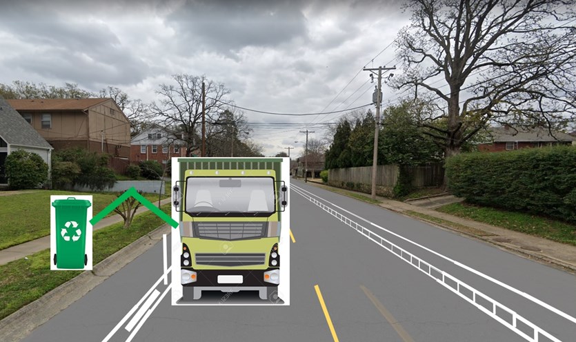
Figure 13. Little Rock's trash and recycle truck arms can extend over the physically protected bike lane to collect containers left on the curb.
Question #17 - Bike Lanes by Van Buren
"Regarding Block 19, between Jackson and Van Buren, how will the intersection change?" Brian T.
Actually, not much.
West half: Traffic flow and parking would not change at all on the west half. There would still be a left turn lane and bicycle traffic would have to merge with vehicular traffic as it does now. There still would not be on-street parking allowed on this half of the block (Fig. 14).
East half: Parking would be removed on the north side of the east half of the block, however, in over 50 parking audits, we never saw a car parked on this part of the block. Parking on the south half of the block would improve by 1) buffering the parked cars with a bike lane and buffer and 2) creating delineated space on the street sufficient to fit vehicles so that residents don't feel the need to park halfway onto the sidewalk (a common occurrence on this block). Parking capacity would more than meet parking need (typically ~1-2 overnight).
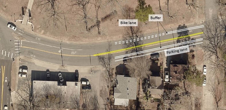
Figure 14. Concept for Kavanaugh bike lanes on Block 19 between N. Jackson and Van Buren.
Question #18 - Lane Width Too Narrow
"If travel lanes are narrowed to 10' wide, how will fire trucks (almost 10 ft. wide themselves from mirror to mirror) get through safely?" Pat & Cathy F.
This is an understandable concern, but it is the discomfort of narrow travel lanes that reduces speeding. Narrowing the travel lanes to 10 ft. wide isn't a compromise to fit in bike lanes; it is a intentional part of the project to slow traffic. Interstate highway travel lanes have a 12 ft. wide lane width standard and invite travel speeds of 75+ mph. When those standards creep into urban streets, they begin to look like highways and people tend to drive at highway speeds. Lane width affects driver behavior. Wider lanes induce speeding, narrower lanes reduce speeding.
Moreover, lanes wider than 10 ft. have a higher risk for high crash severity. To be blunt, the Little Rock metro area has a car vs. pedestrian safety problem. Even though pedestrian safety is a City "Must Do" policy, the latest three Smart Growth America Dangerous by Design reports show that we are one of the most dangerous places to walk in the country. Kavanaugh has a posted speed limit of 30 mph, but its design speed is higher, which induces speeding. The difference in pedestrian visibility and car vs. pedestrian crash outcomes at 30mph vs. 40mph is dramatic (Fig. 9).
Practically, when a fire truck comes through in an emergency, vehicles can pull over into the buffer and bike lane on the parallel parking side to get out of the way. That is a 10 ft. (vehicular lane) + 10 ft. (vehicular lane) + ~2 ft. (bike lane buffer) +~5 ft. (bike lane) = 27 ft. of width for a fire truck >10 ft. wide and a vehicle > 8 ft. wide to navigate around each other. Ten foot travel lanes have been installed in urban areas across the country with no issue and, in fact until recently, the Little Rock Fire Department Station #2 had four 9 ft. wide lanes in front of it without incident.
The ITE Traffic Engineering Handbook 7th Edition states that "Ten feet should be the default width for general purpose lanes at speeds of 45 mph or less." LRFD is in the business of public safety and saving lives; 10 ft. wide travel lanes are a proven way to do this.
"Lane widths of 10 feet are appropriate in urban areas and have a positive impact on a street's safety without impacting traffic operations." National Association of City Transportation Officials (NACTO).
Comment #19 - Parking at Ridgeway Apartment Complex
"There is an 18 unit apartment building at Kavanaugh and Ridgeway that will open soon. Parking counts are artificially low in this location because that apartment building is not currently open." Pat & Cathy F.
The blocks relevant to this discussion are "Block 9" and "Block 10" (Fig. 1). With the proposed changes, Block 9 would have 12 parallel parking spots and Block 10 would have 10 parallel parking spots on Kavanaugh (Fig. 1). It is true that much of our data was collected by direct observation in 2021, however we have used all available Google streetview images to better understand historic parking demand from 2007-2019.
If measured parking demand for Blocks 9 and 10 were artificially low because of this renovation, parking use from 2007-2011 should be higher than directly observed parking use. It is not (see day and night parking data and below or see for yourself). However, Google streetview data only include parking demand in the daytime. How can we know whether or not historic night parking demand was affected by the operating apartment complex?
There is a strong relationship between a block's day parking demand and night parking demand. If all blocks are considered, day parking demand explains 71% of the variation of night parking demand (Fig. 15). If Block 17 is removed, the outlier on Fig. 19 because it functions more like business district parking with daytime parking demand far higher than night parking demand (see also Comment #12), day parking demand explains 96% of the variation in night parking demand (Fig. 16). Because historic day parking demand is no higher than 2021 parking demand, Figures 15 and 16 provide strong evidence that historic night parking demand is no higher than 2021.
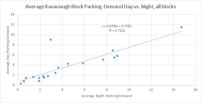
Figure 15. Relationship between day vs. night parking demand by block. The outlier is "Block 17" which has a parking pattern more reflective of the Hillcrest Business District, with higher daytime demand than nighttime demand.
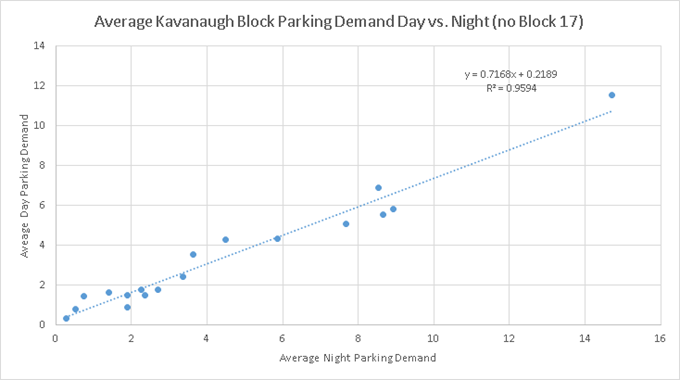
Figure 16. Relationship between a block's daytime vs. nighttime parking demand excluding "Block 17".
In sum, by using direct observations and historic observations, we can be confident that parking demand on Blocks 9 and 10, day or night, has not come close to the parking capacity these blocks would have with bike lanes from 2007-present.
Block 9
Capacity with bike lanes = 12
Average day parking, May-August 2021 (direct observations) = 4.33 mean / 4.5 median
Average day parking, historic (Google streetview, 2007-2019) = 4.33 mean / 4 median
Average night parking, May-August 2021 (direct observations) = 5.9 mean / 6 median
Estimated night parking, historic (2007-2019) via regression equation = (4.33-0.2189)/0.7168 = 5.74 cars
(Block 9 would have a 12 car parallel parking capacity with bike lanes)
Block 10
Capacity with bike lanes = 10
Average day parking (direct observations) = 1.67 mean / 2 median
Historic day parking (Google streetview, 2007-2019) = 1.0 mean / 1 median
Average night parking, May-August 2021 (direct observations) = 2.4 mean / 2 median
Estimated night parking, historic (2007-2019) via regression equation = (1-0.2189)/0.7168 = 1.09 cars
(Block 10 would have a 10 car parallel parking capacity with bike lanes)
Question #20 - Taxes and Project Financial Expense
"Taxes are levied on motor vehicles to pay for street maintenance. Why should they pay for bike infrastructure?" Pat F.
"the project would be a large expense for a small amount of users" HRA Letter, April 2022
20a) Kavanaugh is not a state or federal highway; its maintenance is not funded through gas tax. The Kavanaugh resurfacing project was paid for by the 2012 Sales Tax and Bond Program, funding sources not tied to motor vehicles.
20b) Kavanaugh is being resurfaced as part of necessary street maintenance. This includes removing and replacing the top layer of asphalt and, with it, all current striping. Restriping will be necessary; any cost difference between restriping with or without bike lanes would be negligible to overall project costs.
20c) The majority of bicycle owners, especially in Little Rock, also own and operate a motor vehicle(s) and pay their associated fees
20d) re: "small amount of users" - See Question 26 below.
Comment #21 - Neighborhood Character
"The Hillcrest neighborhood takes great pride in its historic designation, and the meandering feel of Kavanaugh Boulevard as it winds through the neighborhood is part of that historic fabric. We are concerned that the physical features of the proposed bike lanes such as barriers, poles, reflectors, and lines would be visual eyesores that would detract from the historic character of the neighborhood. In particular, people are concerned about the plastic bollards that tend to weather and become unsightly over time." - HRA Letter, April 2022
The Hillcrest neighborhood, and Kavanaugh Blvd. in particular, is (historically) one of Little Rock's quintessential multi-modal corridors (Fig. 17). In Kavanaugh Blvd.'s early days, when it was called Prospect Ave., it didn't have much vehicular traffic. In fact, many residences didn't have driveways or garages because they commuted by the trolley, which ran from downtown to Stifft Station, to Hillcrest, to the Heights, where it turned around in the heart of what is now the Heights business district. Even today some residences don't have driveways or garages along Kavanaugh (especially close to Stifft Station) because of this history, a reason that maintaining parallel parking on Kavanaugh is so important.
Sadly, according to many residents, Kavanaugh Blvd. now only welcomes cars. Those cars move too fast, speed induced by ridiculously wide 21 ft. lanes in the absence of parallel parked cars, which are not typically dense (Question #18). This does not represent Kavanaugh Blvd.'s historic condition or its historic use. Today what it takes to be a safe and welcoming multi-modal corridor has changed, and indeed the modalities have changed. But together we could bring this corridor back to being safe, multimodal neighborhood corridor as depicted in this penny postcard.
"I've been almost hit by cars several times using the cross-walk because cars do not respect the pedestrian presence in the neighborhood." Ashlee S.
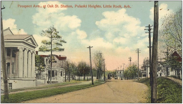
Figure 17a. The historic configuration of Prospect Ave. (now Kavanaugh Blvd.).
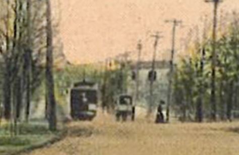
Figure 17b. Zoomed in to show Prospect Ave.'s three street users, the trolley, a horse and buggy, and a pedestrian crossing the street.
Comment #22 - Aesthetics
"We are concerned that the physical features of the proposed bike lanes such as barriers, poles, reflectors, and lines would be visual eyesores that would detract from the historic character of the neighborhood. In particular, people are concerned about the plastic bollards that tend to weather and become unsightly over time." - HRA Letter, April 2022
The City is making every effort to work with HRA, it's historic ethic, and its aesthetics. We can consider different types of bollards (today's bollards are more rugged and, between parking stops, they would also not get the abuses that have damaged others in the City) or even consider physical projections without bollards (with the permission of the granting agency). The City has met with a subset of the HRA twice to consider the aesthetics of this corridor and are committed to doing everything we can to accommodate their needs.
Physically protected bike lanes can be an excellent match to a healthy and vibrant historic neighborhood whose residents enjoy seeing each other face to face rather than through the glass of a windshield (Fig. 18). Creating a street that welcomes cycling tends to increase neighborhood cohesion.
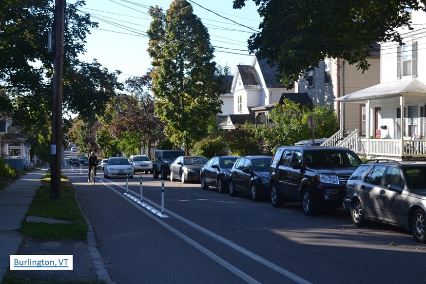
Figure 18. Physically protected bike lane in a historic Vermont neighborhood... that's likely a 10 ft. vehicular lane (Question #18).
Comment #23 - Pop Up
"Perhaps a taped-out mockup could be arranged to help with the visualization on this very important street through Hillcrest." HRA Letter, April 2022
Pop ups, by their nature, are not pretty (using found materials, jerry rigging, etc.). If the primary concern were the function of the street with bike lanes, a pop up could be very useful. If the primary concern is aesthetics, the pop up will likely do little to address that concern fairly. However the HRA was very eager to install a pop-up and the City was eager to work with the HRA to make the facility best fit the neighborhood, so the pop up was installed in October 2022 (Fig. 19).
Figure 19. Kavanaugh bike lane pop up from Ridgeway to Oak.
Question #24 - Can't you just put the bike lanes somewhere else?
(proposed locations have included Markham, Lee, and Woodlawn).
Unfortunately, the short answer is "no". Bike lanes are transportation facilities. We can no more put a bike facility somewhere else and have it serve the same function as we could put a street somewhere else and have it serve the same function. Kavanaugh will be part of a planned bicycle transportation network that connects together like pieces of a jigsaw puzzle. The Kavanaugh bike lanes will immediately connect to existing facilities on Van Buren, Allsopp Park, and the I-630 bridge via Booker (Fig. 18). It also creates a transportation corridor to downtown via 7th Street or Cedar Hill (Fig. 20). Near term planned facilities will make connectivity on Kavanaugh even more important (Fig. 20). Neither Markham nor Woodlawn nor any other street has equivalent connectivity in Hillcrest or for the City's bicycle network. Lee is also too narrow for bike facilities and Markham's topography create safety challenges with sightlines and speed differentials.
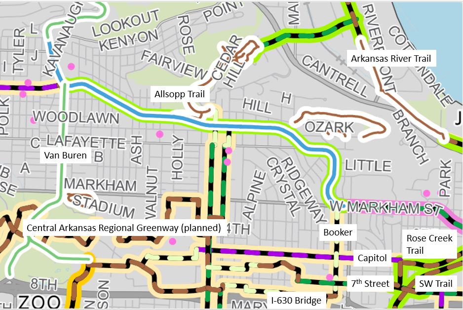
Figure 20. Only Kavanaugh will create a functional bicycle network.
Comment #25 - Little demand for bike commuting in Hillcrest
"The consensus in the Hillcrest neighborhood is that there is very little demand for this [project / bike commuting in Hillcrest]" HRA Letter, April 2022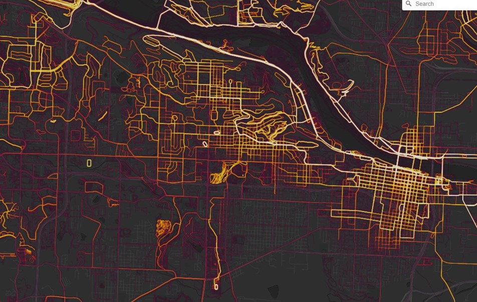
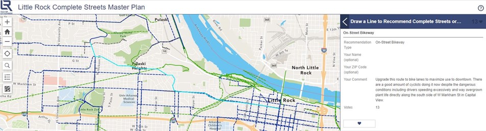
Figure 22. Kavanaugh on the Complete Streets: Bicycle Plan Interactive Map.
Question #26 - Who Benefits?
"Why change for a narrow special interest?" Randy J. and Samuel W.
As noted in Benefits, improving conditions for bicycle transportation does not just benefit people who ride bikes. Bike lanes on Kavanaugh would benefit the comfort and safety of all street users and residents along Kavanaugh. They would help our local businesses and keep our wealth in Little Rock. This proposal would raise Hillcrest’s property values and help strengthen Hillcrest’s community by increasing social interaction. It would increase community health and decrease our transportation carbon footprint. It would allow current residents to age in place and allow more independence for their children. This is why the City of Little Rock supports Complete Streets in its Resolution, Ordinance, goals, agenda, policy statements, and Mission/Vision. Kavanaugh is an identified bike corridor in our adopted Master Bike Plan, obligating the City to consider the suitability of this corridor for bike transportation in resurfacing projects, the Federal Highway Administration Bikeway Selection Guide, our Complete Streets Master Plan contractor (ALTA Planning + Design), and US DOT / FHWA staff considering the Kavanaugh corridor specifically consider sharrows insufficiently protective for Kavanaugh.
"It will increase property values in the area and along the street, it will encourage healthy living (biking and walking), it will slow the cars down, which is a problem right now in our city. It is win-win-win all the way around. I love the design the city has proposed, and fully support it." Ed L.
